
Screenshots
About iStreams - Lands End
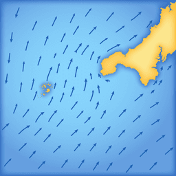
iStreams - Lands End gives sailors and navigators instant access to precise tidal stream charts aligned to real-time conditions at Devonport High Water—with or without an internet connection.
Whether you're passage planning, navigating coastal waters, or sailing in challenging tidal zones, understanding tidal flow is essential to safe and efficient navigation. iStreams delivers the Lands End tidal stream atlas in your pocket, automatically displaying the correct hourly chart based on the nearest High Water time. No guesswork, no manual lookups—just accurate data when you need it most.
The app works entirely offline, meaning you can access all charts and core tools without any signal. Simply swipe forward and backward through tidal hours to view past or future conditions, pinch to zoom for detailed exploration, and drag across the chart to examine specific areas. The interface automatically updates as time progresses, switching to the next valid tidal period so your navigation planning stays current. Toggle between Local Time and UTC depending on your preference, and overlay your boat position directly on the chart for real-time situational awareness.
Beyond basic chart viewing, iStreams includes practical navigation tools to enhance your decision-making. The Interpolated Rate Calculator lets you instantly compute stream rates between neap and spring tides, eliminating manual calculations in the moment. For those who need precision, optional in-app tools—the Tidal Set Tool and Course to Steer calculator—provide advanced functionality: measure the true direction of tidal stream arrows with accuracy, or calculate the correct heading needed to maintain your intended course despite tidal drift.
Designed specifically for sailors, navigators, and coastal users, iStreams combines accuracy with simplicity. The fast, clear interface puts critical information within seconds of opening the app, so you can make confident decisions on the water. Whether you're planning a passage days ahead or checking conditions in real time, iStreams - Lands End keeps you informed and in control.
Pros & Cons
Pros
- Works fully offline with no internet connection required
- Automatically displays correct tidal chart based on real-time High Water
- Includes practical tools like rate calculator and course-to-steer computation
- Overlay your boat position directly on tidal stream charts
Cons
- Limited to Lands End region—not usable for other UK or international waters
- Advanced tools like Tidal Set and Course to Steer require in-app purchases
- Manual chart navigation by swiping may become tedious during extended planning sessions
- Offline-only design means no updates to tidal data without reinstalling app
Related Apps

EasyPark - Parking made easy
EasyPark AS
Parking app with pay-per-minute rates, EV charging, and coverage across 20+ countries—EasyPark

São Paulo Airport Guide - GRU
TrackingTopia
Airport guide for São Paulo GRU & CGH with real-time flights, maps & wifi info

GRU Airport
Thera Solutions
São Paulo airport app with flight status, maps, dining, and services — GRU Airport official

Heathrow Airport (LHR) Info
Sinecloud
Live flight info, airport details, and trip planning tools for London Heathrow (LHR).

SAR
SAUDI ARABIA RAILWAYS
Book train tickets and manage reservations with Saudi Arabia Railways' official SAR mobile app.

OpenTable
OpenTable
Find and book restaurants instantly. Browse 65,000+ venues, read reviews, manage reservations with OpenTable.
Latest Articles

Best AI admin task automation apps for desktop in 2026 (we tested 7)
Jul 11, 2026

Best AI coding tutor apps for desktop in 2026 (we tested 7)
Jul 11, 2026
Best apps for AI red teaming on desktop in 2026 (free and paid)
Jul 11, 2026

Best apps for the *arr media stack on desktop in 2026 (we tested 7)
Jul 11, 2026
Best apps for benchmarking local LLMs on desktop in 2026 (free and paid)
Jul 11, 2026